Article-Journal

Connected Traffic Signal Coordination Optimization Framework through Network-Wide Adaptive Linear Quadratic Regulator–Based Control Strategy featured image

Connected Traffic Signal Coordination Optimization Framework through Network-Wide Adaptive Linear Quadratic Regulator–Based Control Strategy

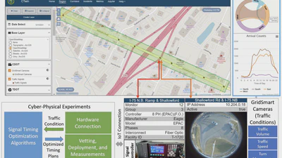
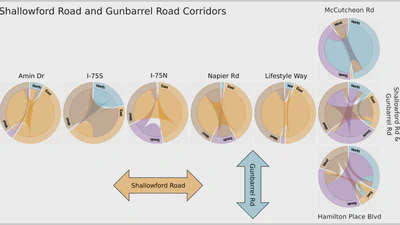
The 8 intersections controlled for the real-world experiments were divided into 3 groups based on the corridors on which they are located.

Jiho Park
Read more
A traffic accident dataset for Chattanooga, Tennessee featured image

A traffic accident dataset for Chattanooga, Tennessee

This dataset combines data from traffic sensors, accident data, weather data, and daylight information into a comprehensive tagged traffic accident dataset. This dataset contains …

avatar
Andreas Berres
Read more
Spatiotemporal features of traffic help reduce automatic accident detection time featured image

Spatiotemporal features of traffic help reduce automatic accident detection time

Automated Incident Detection (AID) pipeline as described in the paper. After the dataset generation phase (which is described in detail in our Data in Briefpublication), we …

Pablo Moriano
Read more
Semi-Automatic Geographic Information System Framework for Creating Photo-Realistic Digital Twin Cities to Support Autonomous Driving Research featured image

Semi-Automatic Geographic Information System Framework for Creating Photo-Realistic Digital Twin Cities to Support Autonomous Driving Research

Real-world road (top) and VR digital twin versions under two different light conditions (middle and bottom).

Haowen Xu
Read more
A Mobile Edge Computing Framework for Traffic Optimization at Urban Intersections Through Cyber-Physical Integration featured image

A Mobile Edge Computing Framework for Traffic Optimization at Urban Intersections Through Cyber-Physical Integration

Setup for dynamometer testing (left) and view from inside the vehicle showing simulated traffic linked to the driver, and a mobile app showing speed recommendations (right).

Haowen Xu
Read more
Smart Mobility in the Cloud: Enabling Real-Time Situational Awareness and Cyber-Physical Control Through a Digital Twin for Traffic featured image

Smart Mobility in the Cloud: Enabling Real-Time Situational Awareness and Cyber-Physical Control Through a Digital Twin for Traffic

Cyber-physical control experiments conducted through the CTwin’s cyberinfrastructure: Connecting traffic light controller at intersections with signal timing optimization …

Haowen Xu
Read more
EPIsembleVis: A geo-visual analysis and comparison of the prediction ensembles of multiple COVID-19 models featured image

EPIsembleVis: A geo-visual analysis and comparison of the prediction ensembles of multiple COVID-19 models

Model selection is performed using a data availability map showing which variables (cases, hospitalizations, deaths) each of the dozens of predictive models includes, and which …

Haowen Xu
Read more
Continuous Emulation and Multiscale Visualization of Traffic Flow Using Stationary Roadside Sensor Data featured image

Continuous Emulation and Multiscale Visualization of Traffic Flow Using Stationary Roadside Sensor Data

Comparison of an animated trails visualization (used at microscopic scale) and our proposed animated strips-network for visualizing lane usage at mesoscopic scale for a section of …

Haowen Xu
Read more
Explorative Visualization for Traffic Safety using Adaptive Study Areas featured image

Explorative Visualization for Traffic Safety using Adaptive Study Areas

The calendar view shows the incident distribution of a selected dataset over time. Each day’s incidents are displayed as a tile on the calendar. When the tile for a day is …

avatar
Andreas Berres
Read more
Multiscale and Multivariate Transportation System Visualization for Shopping District Traffic and Regional Traffic featured image

Multiscale and Multivariate Transportation System Visualization for Shopping District Traffic and Regional Traffic

Chord charts for intersection-level visualization for a single day (Tuesday, April 2, 2019) in Chattanooga, Tennessee. The horizontally placed charts represent the intersections …

avatar
Andreas Berres
Read more