Connected Traffic Signal Coordination Optimization Framework through Network-Wide Adaptive Linear Quadratic Regulator–Based Control Strategy
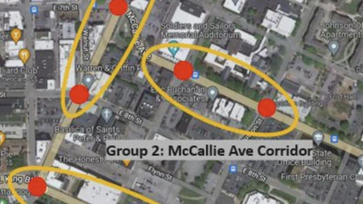
The 8 intersections controlled for the real-world experiments were divided into 3 groups based on the corridors on which they are located.
Jiho Park
•
•
1 min read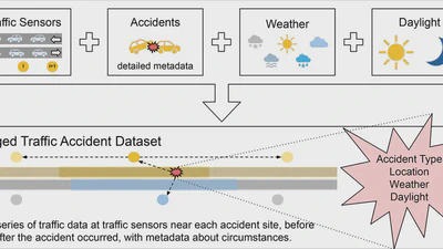
A traffic accident dataset for Chattanooga, Tennessee
This dataset combines data from traffic sensors, accident data, weather data, and daylight information into a comprehensive tagged traffic accident dataset. This dataset contains …
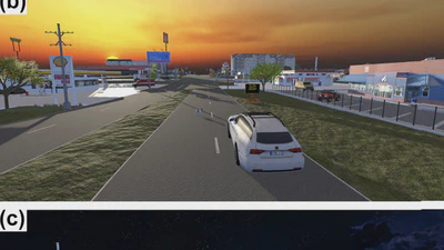
Semi-Automatic Geographic Information System Framework for Creating Photo-Realistic Digital Twin Cities to Support Autonomous Driving Research
Real-world road (top) and VR digital twin versions under two different light conditions (middle and bottom).
Haowen Xu
•
•
1 min read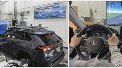
A Mobile Edge Computing Framework for Traffic Optimization at Urban Intersections Through Cyber-Physical Integration
Setup for dynamometer testing (left) and view from inside the vehicle showing simulated traffic linked to the driver, and a mobile app showing speed recommendations (right).
Haowen Xu
•
•
1 min read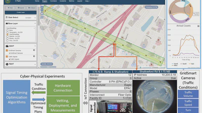
Smart Mobility in the Cloud: Enabling Real-Time Situational Awareness and Cyber-Physical Control Through a Digital Twin for Traffic
Cyber-physical control experiments conducted through the CTwin’s cyberinfrastructure: Connecting traffic light controller at intersections with signal timing optimization …
Haowen Xu
•
•
1 min read
A Mobile App for Intersectional Traffic Optimization through Real-Time Vehicle-to-Infrastructure (V2I) Communication and Cyber-Physical Control
Overview of the mobile app developed to provide driving recommendations based on vehicle location and the traffic signal state that is managed via a cloud-based communication …
Haowen Xu
•
•
1 min read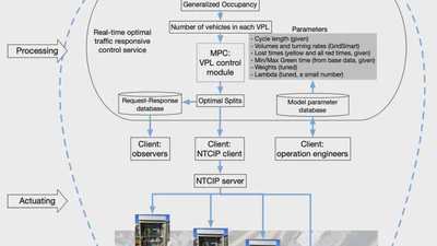
Deploying a Model Predictive Traffic Signal Control Algorithm - A Field Deployment Experiment Case Study
Architecture diagram illustrating the workflow for real-time traffic signal control for our field experiments. GridSmart traffic data and TomTom speeds were preprocessed to feed …
Qichao Wang
•
•
1 min read
Computer Vision-Enabled Smart Traffic Monitoring for Sustainable Transportation Management
Overview of available traffic signals, camera infrastructure, and parking lot locations on ORNL campus.
Yunli Shao
•
•
1 min read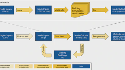
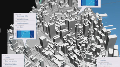
A Data-Driven Approach to Nation-Scale Building Energy Modeling
High-level workflow for large-scale building simulation with AutoBEM: The bottom part of the workflow represents the overall workflow while the top portion provides more detail …