Transportation

A Mobile App for Intersectional Traffic Optimization through Real-Time Vehicle-to-Infrastructure (V2I) Communication and Cyber-Physical Control featured image

A Mobile App for Intersectional Traffic Optimization through Real-Time Vehicle-to-Infrastructure (V2I) Communication and Cyber-Physical Control

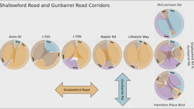
Overview of the mobile app developed to provide driving recommendations based on vehicle location and the traffic signal state that is managed via a cloud-based communication …

Haowen Xu
Read more
Deploying a Model Predictive Traffic Signal Control Algorithm - A Field Deployment Experiment Case Study featured image

Deploying a Model Predictive Traffic Signal Control Algorithm - A Field Deployment Experiment Case Study

Architecture diagram illustrating the workflow for real-time traffic signal control for our field experiments. GridSmart traffic data and TomTom speeds were preprocessed to feed …

Qichao Wang
Read more

Campus Digital Twin

Selected Publications: Computer Vision Based Traffic Monitoring Virtual Reality Digital Twins of Smart Cities

Read more
Computer Vision-Enabled Smart Traffic Monitoring for Sustainable Transportation Management featured image

Computer Vision-Enabled Smart Traffic Monitoring for Sustainable Transportation Management

Overview of available traffic signals, camera infrastructure, and parking lot locations on ORNL campus.

Yunli Shao
Read more
Generating traffic-based building occupancy schedules in Chattanooga, Tennessee from a grid of traffic sensors featured image

Generating traffic-based building occupancy schedules in Chattanooga, Tennessee from a grid of traffic sensors

An overview of the methodology presented in this paper, guided by the data workflow. The left-hand side of the figure, (a)-(d), illustrates the traffic data workflow: the data is …

avatar
Andreas Berres
Read more
Continuous Emulation and Multiscale Visualization of Traffic Flow Using Stationary Roadside Sensor Data featured image

Continuous Emulation and Multiscale Visualization of Traffic Flow Using Stationary Roadside Sensor Data

Comparison of an animated trails visualization (used at microscopic scale) and our proposed animated strips-network for visualizing lane usage at mesoscopic scale for a section of …

Haowen Xu
Read more
Explorative Visualization for Traffic Safety using Adaptive Study Areas featured image

Explorative Visualization for Traffic Safety using Adaptive Study Areas

The calendar view shows the incident distribution of a selected dataset over time. Each day’s incidents are displayed as a tile on the calendar. When the tile for a day is …

avatar
Andreas Berres
Read more
Multiscale and Multivariate Transportation System Visualization for Shopping District Traffic and Regional Traffic featured image

Multiscale and Multivariate Transportation System Visualization for Shopping District Traffic and Regional Traffic

Chord charts for intersection-level visualization for a single day (Tuesday, April 2, 2019) in Chattanooga, Tennessee. The horizontally placed charts represent the intersections …

avatar
Andreas Berres
Read more
A Mobility-Driven Approach to Modeling Building Energy featured image

A Mobility-Driven Approach to Modeling Building Energy

Left: The traffic simulation area (yellow) within the Chicago area (red). Middle: Simulated buildings in the Chicago Loop (blue). Right: 3D rendering of buildings in the Chicago …

avatar
Andreas Berres
Read more